Another level 8 severe storm warning for South Africa

The South African Weather Service (SAWS) has issued another level 8 severe storm warning, alerting the country to a cold front that will hit the Eastern and Western Cape this week.
According to SAWS, Orange Level 8 and Yellow Level 4 warnings for disruptive rainfall have been issued for areas including the Garden Route, Swellendam Municipality and the Central Karoo.
The weather system is expected to affect the eastern parts of the Western Cape between 3 and 4 June 2026.
SAWS said rainfall accumulations of between 50mm and 90mm are expected over the Central Karoo, western parts of the Garden Route District and Swellendam Municipality, prompting the Yellow Level 4 warning.
However, significantly heavier rainfall of 150-200mm is possible over the eastern Garden Route District, resulting in the Orange Level 8 warning.
The weather service added that even higher rainfall totals could occur in mountainous regions.
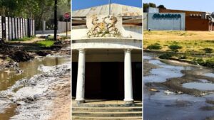
The warning comes as many parts of the province are still recovering from severe weather experienced in May.
SAWS noted that the affected regions remain particularly vulnerable due to saturated ground conditions and dams that are already near capacity or overflowing.
“Given the current vulnerability of these regions following the severe weather system in May, as well as the near full or overflowing dams, significant impacts are possible,” the weather service said.
Forecasters warned that flooding of roads, formal and informal settlements is likely and could result in infrastructure damage and the displacement of vulnerable communities.
Fast-flowing rivers and deep water may also pose a danger to life, while some communities could become inaccessible or isolated for extended periods.
The expected rainfall may also cause major disruptions to transport networks. Roads could be flooded or damaged, increasing travel times and limiting access to certain areas.
SAWS further warned of possible mudslides and rockfalls, particularly along mountain passes, as well as damage to property, farm infrastructure, dam walls and livestock.


Residents urged to remain on high alert
The weather service stressed that uncertainty remains regarding the exact distribution and intensity of the rainfall, and that forecasts will continue to be updated as the event approaches.
“Members of the public and stakeholders are strongly urged to continuously monitor official SAWS forecasts and warnings, as warnings will be updated as the likelihood and severity of impacts become clearer,” it said.
SAWS has advised residents to avoid unnecessary travel during periods of heavy rain and flooding, and never attempt to cross flooded roads, bridges or swollen rivers.
People are also encouraged to secure loose outdoor objects, avoid coastal recreational activities during the warning period and ensure livestock and pets have adequate shelter and protection.
The latest warning follows a devastating severe weather event that struck the Western Cape between 10 and 13 May 2026.
Consecutive cold fronts and severe storms caused widespread flooding and destruction across the province, claiming at least 11 lives.
More than 83,000 people were affected, while over 21,000 homes sustained damage. The agricultural sector was also heavily impacted, with damage estimated in the billions of rands.
Areas including Grabouw, Ceres, Worcester and the Hex River Valley suffered extensive losses to vineyards, orchards and crops, while some apple farmers in Grabouw reported losing entire harvests.
With another major rainfall event now forecast, authorities and communities across the affected regions are being urged to remain on high alert and activate contingency plans where necessary.