New Gautrain stations and routes revealed – including 45km of tunnels
The proposed new routes and stations for the Gautrain have been officially gazetted.
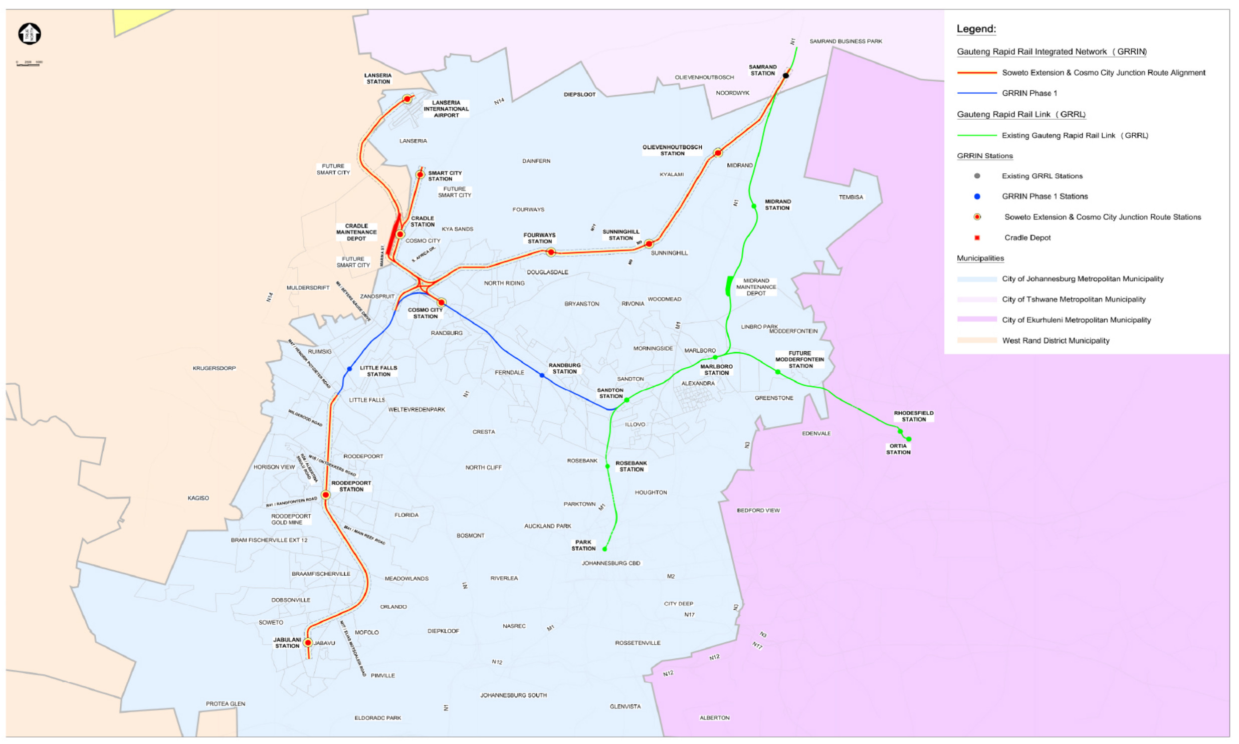
The routes form the Gauteng Rapid Rail Integrated Network (GRRIN), the next major expansion of the Gautrain Rapid Rail Link (GRRL) system, which is already in operation.
Notice has been given under the Gauteng Transport Infrastructure Act outlining the proposed routes.
This follows announcements from the Gauteng Provincial Government over the past few weeks of an imminent release of details for the network expansion.
Government officials noted that the new Gautrain will go to Soweto, Mamelodi, Springs, Atteridgeville, Fourways, and parts of the West Rand.
With the new routes, many new stations are being proposed, including:
- Jabulani Station
- Roodepoort Station
- Lanseria Station
- Cradle Station
- Smart City Station
- Samrand Station
- Fourways Station
- Sunninghill Station
- Olievenhoutbosch Station
According to the notice, the proposed route determination for the provincial rail line has been confirmed for the Soweto Extension and the Cosmo City Junction.
This is in addition to the GRRIN Phase 1 expansion, which plans to expand the GRRL route between Sandton and Little Falls, with the Cosmo City and Randburg Stations along the way.
The notice also puts into effect a number of regulatory measures that now need to be considered, such as any future applications to establish townships or subdivisions of land needing to take the routes into account.
The route determination includes these key proposals:
Little Falls Station to Jabulani Station (Soweto) through Roodepoort Station.
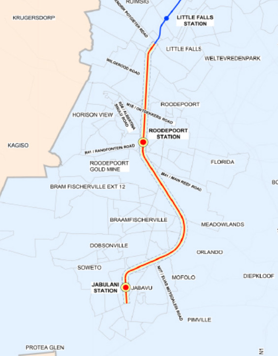
The proposed route begins at the end of the GRRIN Phase 1 route, near the M47 (Hendrik Potgieter Road), approximately 1.6km south of Little Falls Station.
This will run entirely underground for about 19.9 kilometres to minimise surface disruption and environmental impacts.
From Little Falls Station, the proposed route runs in the southerly direction, passing under the suburbs of Helderkruin and Horizon View, before turning parallel to the PRASA line to the proposed Roodepoort Station.
Platforms here are planned to remain underground, while the station building is planned to be developed above-ground.
From the proposed Roodepoort Station, the alignment deviates around Braamfischerville, parts of Meadowlands West and Dobsonville to avoid dolomite areas.
The proposed route passes under the R41 and M77, and crosses previously mined zones, including the Afrisam Roodepoort plant.
A tunnelled route then continues under Meadowlands East, Mofolo North, and Jabavu, reaching the proposed Jabulani Station, which will be similar to Roodepoort Station’s design.
Cosmo Station to Lanseria Station through Cradle Station and Smart City Station
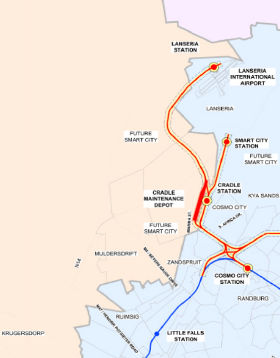
The proposed route starts at the Cosmo City platform as defined by the GRRIN Phase 1 route, and spans approximately 17.4km entirely above ground, with about 7km on elevated bridge structures (viaducts).
Beginning on an elevated section at Cosmo City Station, the planned route heads north-west through vacant land, crossing South Africa Drive through overhead viaducts to the proposed Cradle Station.
From Cradle Station, the route continues north-westerly, crossing the R114 and N14 via a viaduct before heading east towards Lanseria Airport.
The proposed route crosses the R552 via a viaduct, terminating at the proposed Lanseria Station, north of the existing Lanseria Airport parking area.
The proposed Smart City route will tie into the proposed Cradle Station route and continue north in an underground tunnel, cutting under the R114, R512 (Malibongwe Drive), and N14, before terminating at the proposed Smart City Station.
The station platforms are expected to be underground, while the station building will be above ground.
Cosmo City Station to Samrand Station through Fourways Station, Sunninghill Station and Olievenhoutbosch Station
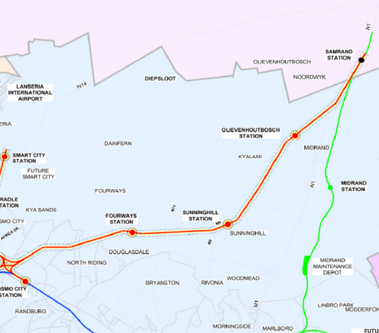
The proposed corridor starts at Cosmo City platforms as defined by the GRRIN Phase 1 route and spans approximately 30.4km, mostly underground (about 25km), with 5km above ground near Cosmo City and Samrand.
Beginning above-ground at Cosmo City, the proposed route heads north-west before turning north-east towards Fourways, crossing the R512 (Malibongwe Drive) by a viaduct.
It enters a tunnel by Hoogland Industrial, just before Witkoppen, continuing underneath the road to the proposed Fourways Station, where platforms will remain underground, and buildings above ground.
From here, the route continues north-east underneath Lonehill towards the proposed Sunninghill Station, similar to Fourways.
The route continues north-east underneath Waterfall, Kyalami, Carlswald and under the R55 (Woodmead Drive), M39 (Allandale Road) towards the proposed Olievenhoutbosch Station, with the same design as Fourways and Sunninghill.
The tunnel route then continues north-east, passing under the N1, R101, the existing Gautrain Rapid Rail Link (GRRL), emerging above-ground to the proposed Samrand Station.
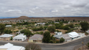
The full route map can be seen below:
The gazette can be found below: