Level 8 severe storm warning for South Africa

The South African Weather Service (SAWS) has issued multiple severe weather warnings for several parts of South Africa.
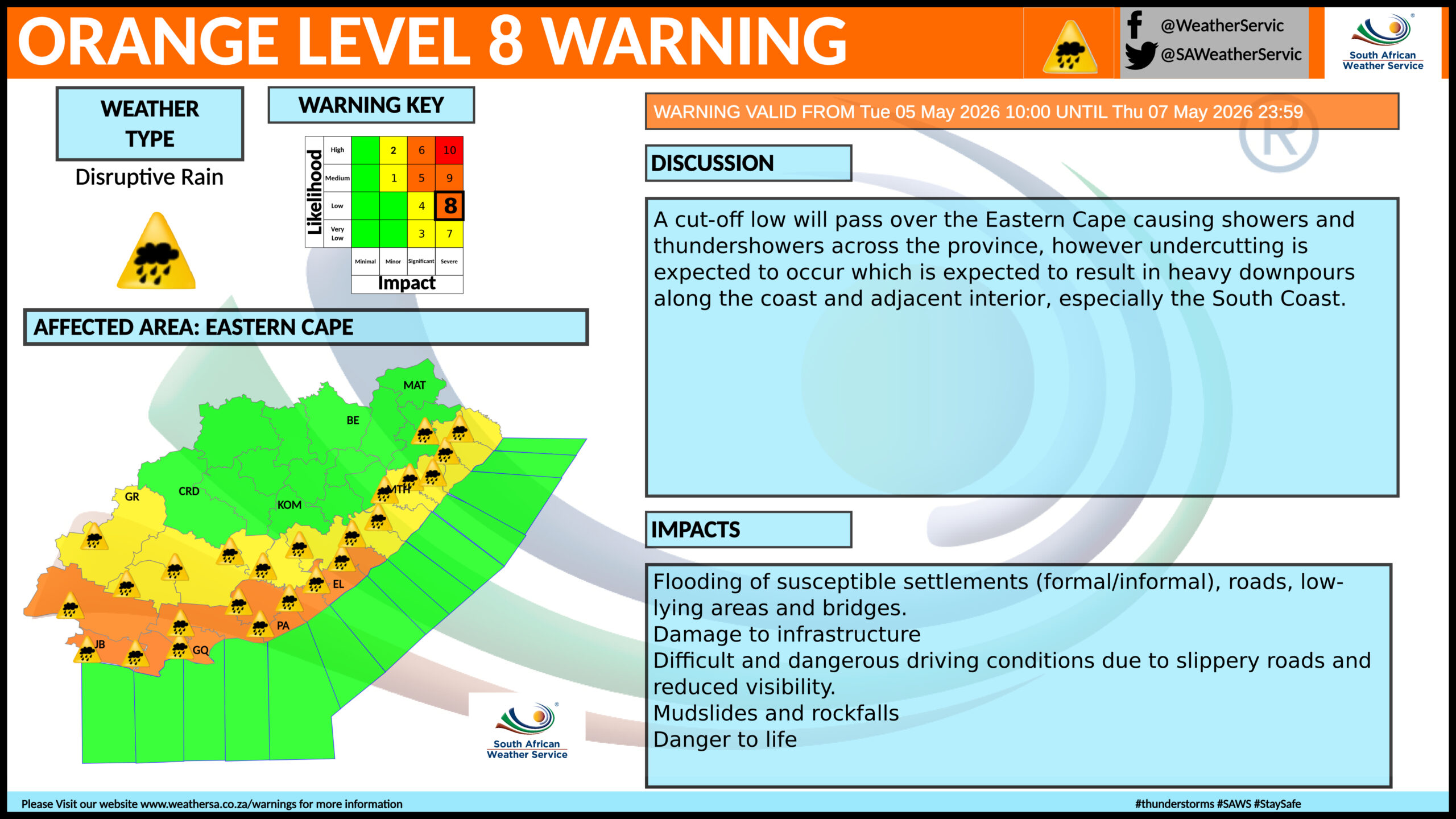
The weather service said South Africans can expect widespread disruptive rainfall, flooding, and dangerous conditions, with storm warnings at levels 2 to 8 in effect from 5 to 7 May 2026.
The most serious conditions are expected in the Western Cape, Eastern Cape, and KwaZulu-Natal, where disaster response teams have been placed on high alert.
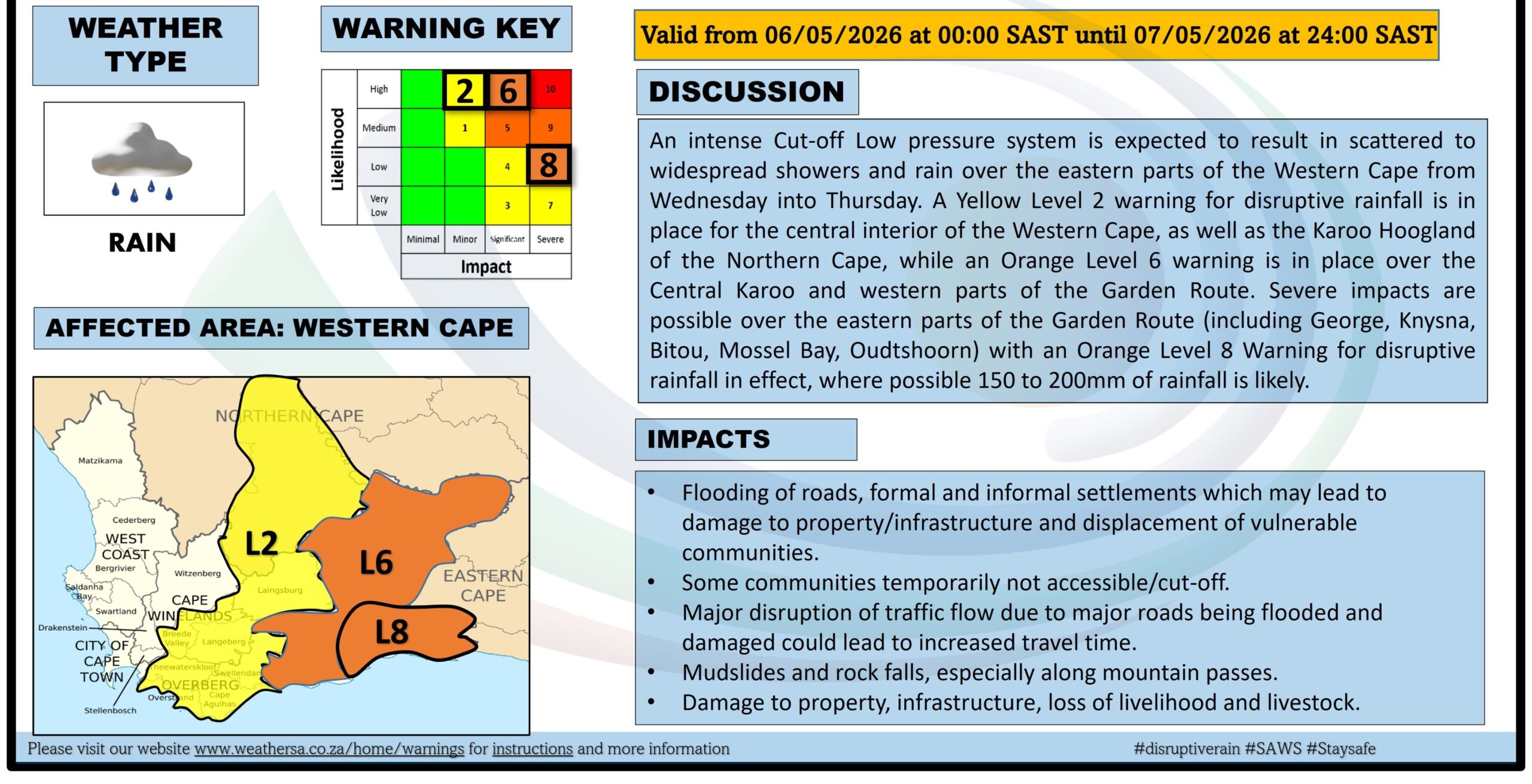
“An intense Cut-off Low pressure system is expected to result in scattered to widespread showers and rain over the eastern parts of the Western Cape from Wednesday into Thursday,” it said.
A Yellow Level 2 warning for disruptive rainfall is in place for the central interior of the Western Cape and the Northern Cape.
An Orange Level 6 warning is in place over the Central Karoo and western parts of the Garden Route. South Africa’s warning levels range from 1 to 10.
The situation has escalated further along the coast, with the Garden Route expected to bear the brunt of the storm.
“Severe impacts are possible over the eastern parts of the Garden Route (including George, Knysna, Bitou, Mossel Bay, Oudtshoorn) with an Orange Level 8 Warning for disruptive rainfall in effect,” SAWS said.
Such rainfall volumes significantly increase the risk of flooding, particularly in low-lying, vulnerable areas.
SAWS warned that impacts could include flooding of roads, formal and informal settlements, which may lead to damage to property and infrastructure.
It added that some communities could become temporarily inaccessible, while major roads may be flooded or damaged, causing travel delays and disruptions.
The risk of mudslides and rockfalls is also elevated, especially along mountainous routes.
Authorities have cautioned that infrastructure damage, livelihood losses, and livestock harm are possible outcomes if conditions worsen.
SAWS has urged the public to remain vigilant and take precautionary measures. “Listen for regular weather updates via radio and/or social media. Postpone travel arrangements until it is safer to travel,” it said.
“Avoid crossing rivers and swollen streams. Monitor the weather conditions and if need be, identify areas to safely store valuable items from flood water,” it said.
Take proactive measures to limit risks
Further inland, parts of Gauteng, including Johannesburg, are also expected to experience severe storms, with yellow level 2 and 4 warnings in place.
Residents in these areas have been advised to exercise caution, particularly on the roads. Be cautious on the roads and avoid crossing rivers and swollen streams where the water is above your ankles.
If trapped in a vehicle during a flood, abandon it and climb to higher ground. In buildings, move valuables to a safe place above the expected flood level.
Insurance experts have also highlighted the heightened risks posed by prolonged cold and wet conditions. Santam noted that preventative maintenance can play a key role in limiting damage to homes.
“For areas hit by downpours and flooding, precautionary measures, such as checking your roof for leaks and clearing your gutters, can help ensure proper water drainage,” said Marius Kemp, Head of Personal Underwriting at Santam.
He added that colder temperatures can worsen the situation by affecting plumbing systems. “The cold weather contributes to the bursting of water pipes,” Kemp said.
He explained that freezing conditions can cause water inside pipes to expand, increasing pressure and leading to cracks or leaks.
Vehicle owners have also been advised to take extra care. Naked Insurance warned motorists to avoid flooded roads wherever possible and to adjust their driving habits in heavy rain.
The insurance company advised that motorists driving in heavy rain should slow down and maintain a safe following distance. In low visibility, turn on your hazards to ensure other drivers can see you.